Filtering the indicators
It is possible to filter the indicator based on type (e.g. state, pressure), category (e.g. core, pre-core) and policy relevance (Baltic Sea Action Plan and Marine Strategy Framework Directive).
Search for Indicators

Grey seal distribution
1 Key message
Distribution of Baltic Grey seals
This core indicator evaluates the state of the marine environment based on the distribution of grey seal (Halichoerus grypus) in the Baltic Sea. The core indicator has three components: Breeding distribution, Moulting distribution and Area of occupancy (i.e. at-sea distribution and access to sites and foraging grounds). Good status is achieved when the distribution of grey seals is close to pristine conditions (e.g. 100 years ago), or where appropriate when currently available haul-out sites are occupied (modern baseline), and when no decrease in area of occupation occurs. The current evaluation covers the assessment period 2016-2021.
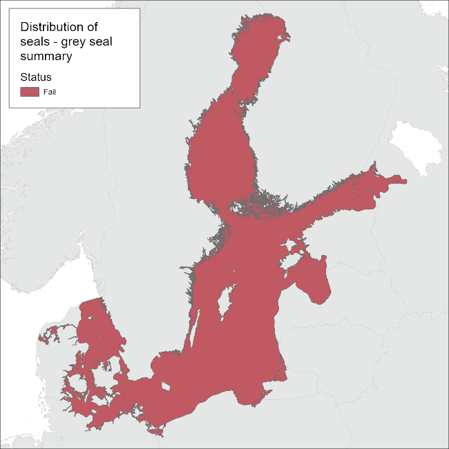
Figure 1. Status evaluation results based on evaluation of the indicator ‘distribution of Baltic Seals’ – Grey seal. The evaluation is carried out using grouping of scale 2 HELCOM assessment units (defined in the HELCOM Monitoring and Assessment Strategy Annex 4) to match with the range of the seal management unit. See ‘data chapter’ for interactive maps and data at the HELCOM Map and Data Service.
State of the Distribution of the Baltic Sea grey seal: The component Area of occupancy for grey seals achieves the threshold value for good status, since grey seals forage in the entire Baltic Sea. For the evaluation of land haul-outs, “modern baseline” is used since some haul-outs in the southern Baltic have vanished due to human exploitation of sand. Grey seals achieve the threshold in most areas of the Baltic except a few HELCOM assessment units in the southwestern areas. Arkona basin, Bay of Mecklenburg, Kiel Bay, Great Belt, the Sound and Kattegat fail for both Breeding and Moulting distribution and, in addition, Bornholm and Gdansk basins fail for Breeding distribution. Considering the one-out-all-out approach, the Baltic grey seal fails to achieve good environmental status for the Distribution.
1.1 Citation
The data and resulting data products (e.g. tables, figures and maps) available on the indicator web page can be used freely given that it is used appropriately and the source is cited. The indicator should be cited as follows:
HELCOM (2023) Distribution of Baltic seals – grey seals. HELCOM core indicator report. Online. [Date Viewed], [Web link].
ISSN 2343-2543.

Harbour porpoise distribution
1. Key message
Distribution of harbour porpoises
This indicator is a HELCOM pre-core indicator.
This HELCOM pre-core indicator is evaluated for the purposes of the ‘State of the Baltic Sea’ report (HOLAS 3) and further development towards a core indicator is expected in the future. An overview of indicator development is set out in the HELCOM indicator manual.
This pre-core indicator evaluates whether the distribution of harbour porpoises (Phocoena phocoena) in the Baltic Sea is adversely affected due to anthropogenic pressures, and thus, if its distributional range and pattern is in line with prevailing physiographic, geographic and climatic conditions. For this expert-based evaluation (currently addresses only one population), good environmental status (GES) for distribution is achieved when the distributional range, and the frequency of harbour porpoise records, in the Baltic Sea is the same as that indicated by historical records (starting from late 17th century), taking confounding factors into account (see Confidence of the qualitative assessment). This is not achieved in the Baltic Proper population (Figure 1).
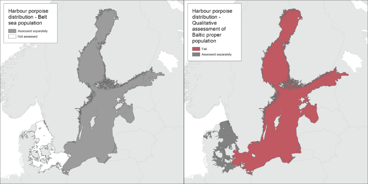
Figure 1. Left: Status evaluation results of the Belt Sea harbour porpoise population-based evaluation of the indicator ‘Distribution of harbour porpoises’ [not yet evaluated]. Right: Status qualitative evaluation results based on an evaluation of the distribution and frequency of historical records of harbour porpoises within the May-October management range of the Baltic Proper harbour porpoise. The evaluation is carried out using Scale 2 HELCOM assessment units (defined in the HELCOM Monitoring and Assessment Strategy Attachment 4). See ‘data chapter’ for interactive maps and data at the HELCOM Map and Data Service.
The HELCOM area is currently inhabited by two separate harbour porpoise populations: (i) the Belt Sea population in southern Kattegat, the Belt Sea, the Sound, and south-western Baltic, and the (ii) the Baltic Proper population in the waters east thereof (Carlén et al., 2018; Sveegaard et al., 2015). While there are reasonable estimates for distribution to support management (especially in relation to summer distribution) there remain some uncertainties, especially with regard to the Baltic Proper population. The evaluation of population distribution is always completed on the population level (based on the results of population level surveys, e.g. SCANS, MiniSCANS and SAMBAH), together with the population level abundance evaluation to determine whether any observed change in distribution is likely to be a positive or negative factor. This two-step process is due to the nature of highly mobile marine species. It is very difficult to assess whether an increase or decrease in distributional range is a good or bad thing without additional information on population status, or ideally, habitat quality over the current range (Owen et al. 2022).
According to the Marine Strategy Framework Directive (MSFD), directional trends can be used as proxies until threshold values are established. Since population-wide surveys do not happen regularly for this species in the region, key site monitoring data will be used to supplement population-wide surveys and assess trends in the distribution at shorter time intervals than if based on population-scale evaluations only. Key site monitoring will occur as a part of ongoing national monitoring programmes, long-term visual or acoustic monitoring, or the establishment of new monitoring programmes at key sites in each country. Trends in distribution are to be evaluated on population-wide data when available. On shorter time scales, a trend in porpoise distribution at key sites is to be evaluated, indicative of potential changes in the population distribution.
The evaluation of the Baltic Proper population is based on data from one passive acoustic monitoring (PAM) survey (SAMBAH) in 2011-2013 (Carlén et al., 2018; Amundin et al., 2022). Due to the very low density of the Baltic Proper population, only dedicated acoustic methods should be applied. The SAMBAH survey identified a summer core area for the Baltic Proper population around the offshore banks, Hoburg’s Bank, and the Northern and Southern Mid-Sea Banks (Carlén et al., 2018).
Due to the lack of appropriate data for a quantitative distribution evaluation, a qualitative evaluation was carried out as part of the HELCOM BLUES project (2021-2022), based on historical information on harbour porpoise occurrence within the May-October management range of the Baltic Proper population (HELCOM, 2022). The expert-based qualitative evaluation show that the distribution of the Baltic Proper harbour porpoise does not achieve good environmental status (Figure 1).
It is currently not possible to make an evaluation of distribution for the Belt Sea population and consequently this population is not described further in this version of the indicator.
This qualitative evaluation evaluates the status of the distribution of the Baltic Proper harbour porpoise. The current abundance and distributional pattern are compared to historical data on harbour porpoise occurrence within the population’s management range. No quantitative thresholds are available, but the comparisons show that the distribution of the Baltic Proper harbour porpoise does not achieve good environmental status. The qualitative evaluation is applicable in the waters of all nine countries bordering the Baltic Sea, including areas such as Bothnian Bay, which often is considered to be outside of the current distributional range of the Baltic Proper harbour porpoise population.
The confidence of the qualitative evaluation is high, although not quantifiable. The confidence in the evaluation is considered high since the results show that the current status is far from previous levels and thus the failure to achieve GES is strongly apparent. The evaluation also utilises extensive spatial and temporal data as its basis.
1.1 Citation
The data and resulting data products (e.g. tables, figures and maps) available on the indicator web page can be used freely given that it is used appropriately and the source is cited. The indicator should be cited as follows:
HELCOM (2023) Distribution of harbour porpoises. HELCOM pre-core indicator report. Online. [Date Viewed], [Web link].
ISSN 2343-2543

Harbour porpoises abundance
1 Key message
Abundance and population trends of harbour porpoises
This indicator is a HELCOM pre-core indicator.
This HELCOM pre-core indicator is evaluated for the purposes of the ‘State of the Baltic Sea’ report (HOLAS 3) and further development towards a core indicator is expected in the future. An overview of indicator development is set out in the HELCOM indicator manual.
This pre-core indicator evaluates whether the absolute abundance and the trend in abundance of harbour porpoises (Phocoena phocoena) in the Baltic Sea is adversely affected due to anthropogenic pressures, and whether its long-term viability is ensured. In an optimal situation, good environmental status (GES) for abundance is achieved when a population’s abundance exceeds the population-specific Limit Reference Level (LRL) with a steady increasing trend towards the population-specific Target Reference Level (TRL). Since these levels and threshold values are not available yet for a quantitative evaluation to be implemented, instead a qualitative, expert-based evaluation was conducted (Figure 1).
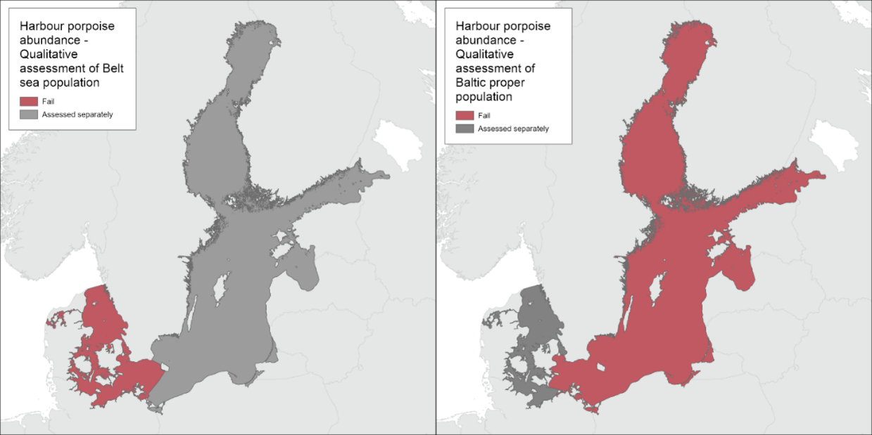
Figure 1. Status qualitative evaluation results based on an evaluation of the trend in abundance and absolute abundance of the Belt Sea harbour porpoise population (left), and of the absolute abundance and historical occurrence of the Baltic Proper harbour porpoise population (right). The qualitative evaluations are carried out using Scale 2 HELCOM assessment units (defined in the HELCOM Monitoring and Assessment Strategy Attachment 4). See ‘data chapter’ for interactive maps and data at the HELCOM Map and Data Service.
The HELCOM area is inhabited by two separate harbour porpoise populations: (i) the Belt Sea population in southern Kattegat, the Belt Sea, the Sound, and south-western Baltic, and the (ii) the Baltic Proper population in the waters east thereof (summer distribution range, winter distribution range uncertain for the Baltic Proper population) (Carlén et al., 2018; Sveegaard et al., 2015). The evaluations are carried out separately for the two populations, and presented on the level of scale 2 HELCOM assessment units aggregated to relevant population scales. The evaluation of absolute abundance and trends are always completed on the population level (assessed using population-level surveys, e.g., SCANS, MiniSCANS or SAMBAH).
Based on the very small current abundance estimate in combination with a drastic reduction in occurrence inferred from the historical records, the abundance of the Baltic Proper harbour porpoise is assessed to not achieve GES. Due to the very low density of the Baltic Proper population, dedicated acoustic methods need to be applied. To date, only one population-wide abundance survey has been carried out in 2011-2013, yielding an abundance of 491 animals (95% CI: 71-1105) (Amundin et al., 2022), and the small population size is enough to conclude that absolute abundance is sub-GES. Due to the lack of appropriate data for a quantitative evaluation of both abundance and trend, a qualitative evaluation was carried out, based on an evaluation of the absolute abundance estimate from SAMBAH in combination with historical records on harbour porpoise occurrence within the May-October management range of the Baltic Proper population. The qualitative evaluation shows that the abundance of the Baltic Proper harbour porpoise has declined over the last century and does not achieve good environmental status (Figure 1).
Similarly, for the Belt Sea population, where a lack of sufficient data as well as thresholds for a robust quantitative evaluation was reported, a qualitative evaluation was carried out, integrating both the absolute abundance and the trend in abundance. For the absolute abundance, the latest abundance estimate of 17,301 harbour porpoises (CV: 0.20) from 2020 was evaluated (Unger et al., 2021). Here, it was decided to assess the abundance against a threshold 10,000 mature individuals. This threshold is suggested by the IUCN, in their Red List of Threatened Species, to define a population to be ‘Vulnerable’ (IUCN, 2012). In 2014, ICES recommended in an advice to OSPAR to consider IUCN quantitative criteria when implementing the Marine Strategy Framework Directive (MSFD) for marine mammals (ICES, 2014) and in 2021, OSPAR adopted this approach (OSPAR, 2021). We assume that the number of mature animals in the Belt Sea population is below 10,000 individuals, as the majority of animals in the population are unlikely to have reached sexual maturity (Kesselring et al., 2017). Thus, the absolute abundance is assessed to not achieve GES.
Two different trend-based approached were utilised to evaluate trends in abundance for the Belt Sea population (Gilles et al., 2022). Considering the available data for the Belt Sea population, for both approaches a trend could only be assessed over a relatively short period of 15 years (2005-2020) since the survey area of the first abundance estimate (SCANS 1994) did not completely cover the distributional range of the population and missed out a large part (30%) of the area in the east. The first method, using a simulation approach by Authier et al., (2020), showed no trend over the study period of 15 years, likely due to less precision and associated large confidence intervals of the earlier surveys. The second approach using a Bayesian trend analysis showed a negative trend (-1.2% p.a.; 95% CI: -3.8% – 4.4%) but associated with a wide credibility interval and 68.5% probability. In conclusion, both analytical approaches showed no statistically significant trend in abundance for the Belt Sea population of harbour porpoises indicating that the trend in abundance has achieved GES. Therefore, the absolute abundance failed GES but the trend in abundance achieved GES. However, when integrating the two evaluations, the “oneoutallout” rule applies, and thus the overall qualitative evaluation of the Belt Sea harbour porpoise population indicates that it does not achieve good environmental status (Figure 1).
The confidence of the qualitative evaluation is considered to be low for the Belt Sea population and high for the Baltic Proper population. The indicator is applicable in the waters of all nine countries bordering the Baltic Sea.
1.1 Citation
The data and resulting data products (e.g. tables, figures and maps) available on the indicator web page can be used freely given that it is used appropriately and the source is cited. The indicator should be cited as follows:
HELCOM (2023) Abundance and population trends of harbour porpoises. HELCOM pre-core indicator report. Online. [Date Viewed], [Web link].
ISSN 2343-2543.

Harbour seal abundance
1 Key message
Population trends and abundance of seals – Harbour seals
This core indicator evaluates the status of the marine environment based on population trends and abundance of the Baltic Sea harbour seal (other seal species are addressed in separate reports). Good status is achieved when i) the abundance of seals in each management unit has attained a Limit Reference Level (LRL) of at least 10,000 individuals to ensure long-term viability and ii) the population trend, assessed by species-specific growth rate, for a population either under or at Target Reference Level (TRL), is achieved, indicating that growth-rates are not affected by severe anthropogenic pressures.
The harbour seal populations in the HELCOM area are currently recognized as two official management units consisting of: (i) Kalmarsund, (ii) southwestern (SW) Baltic Sea and the Kattegat. Here we also assess a third unofficial unit, (iii) the Limfjord.
Multiple lines of evidence suggest that Kattegat and SW Baltic harbour seals are demographically independent, but currently they are officially recognised as one unit (on the basis of HELCOM RECOMMENDATION 27-28/21). Here they will be evaluated in line with the evaluation under HOLAS II: abundance will be evaluated using the combined abundance of the two areas, whereas trends will be evaluated for each area independently. Finally, harbour seals in the Limfjord are not related to other units in the HELCOM area, but as they are not recognised as a separate unit under HELCOM, thus their additional evaluation here must be regarded as unofficial.
The evaluation for population trends is based on data from 2003-2021, since long-term time-series are needed to detect changes in population growth rates. Data from the assessment period 2016-2021 is used to assess population abundance.
All assessed harbour seal management units fail to achieve good environmental status (GES) because they fail the thresholds for both the population abundance and population trend evaluation (Figure 1).
Kalmarsund harbour seals have increased with a rate very close to the threshold for good status, but their abundance is still well below the LRL and thus, status for the subpopulation is not good.
The SW Baltic population alone is below LRL, but when assessed together with Kattegat, the combined abundance exceeds LRL. The growth rate in SW Baltic however is still below the threshold, which results in a sub-GES status. Abundance in Kattegat exceeds LRL, but growth rate is below the threshold when assessed as below TRL and the unit does not achieve good status. However, it is uncertain if the Kattegat unit is at or below TRL or undergoing a decline. Both abundance and growth rate of harbour seals in Limfjord are low and they do not achieve good status.
The confidence of the evaluation for population abundance for all three management units is considered high. The confidence for the evaluation for population trends for SW Baltic Sea is high, whilst the confidence for the Kalmarsund and the Limfjord is moderate and for the Kattegat low.
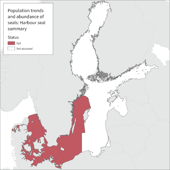
Figure 1. The overall status evaluation results based on the indicator ‘population trends and abundance of seals’ – Harbour seals. The evaluation is carried out using Scale 2 HELCOM assessment units (defined in the HELCOM Monitoring and Assessment Strategy Attachment 4), using the one-out-all-out approach. Thus, if a seal management unit, in not good status, has a given HELCOM assessment unit as part of its range, the assessment unit is marked red. See ‘data chapter’ for interactive maps and data at the HELCOM Map and Data Service.
1.1 Citation
The data and resulting data products (e.g. tables, figures and maps) available on the indicator web page can be used freely given that it is used appropriately and the source is cited. The indicator should be cited as follows:
HELCOM (2023) Population trends and abundance of seals. HELCOM core indicator report. Online. [Date Viewed], [Web link].

Harbour seal distribution
1 Key message
Distribution of Baltic Harbour seals
This core indicator evaluates the state of the marine environment based on the distribution of harbour seals that occur in the Baltic Sea. The core indicator has three components: Breeding distribution, Moulting distribution and Area of occupancy (i.e. at-sea distribution). Good status is achieved when the distribution of seals is close to pristine conditions (i.e. 100 years ago), or where appropriate when currently available haul-out sites are occupied (modern baseline), and when no decrease in area of occupation occurs. The current evaluation covers the assessment period 2016-2021. For the distribution indicator, the subpopulations Kalmarsund, and the group consisting of the SW Baltic, Kattegat and Limfjord are assessed independently.
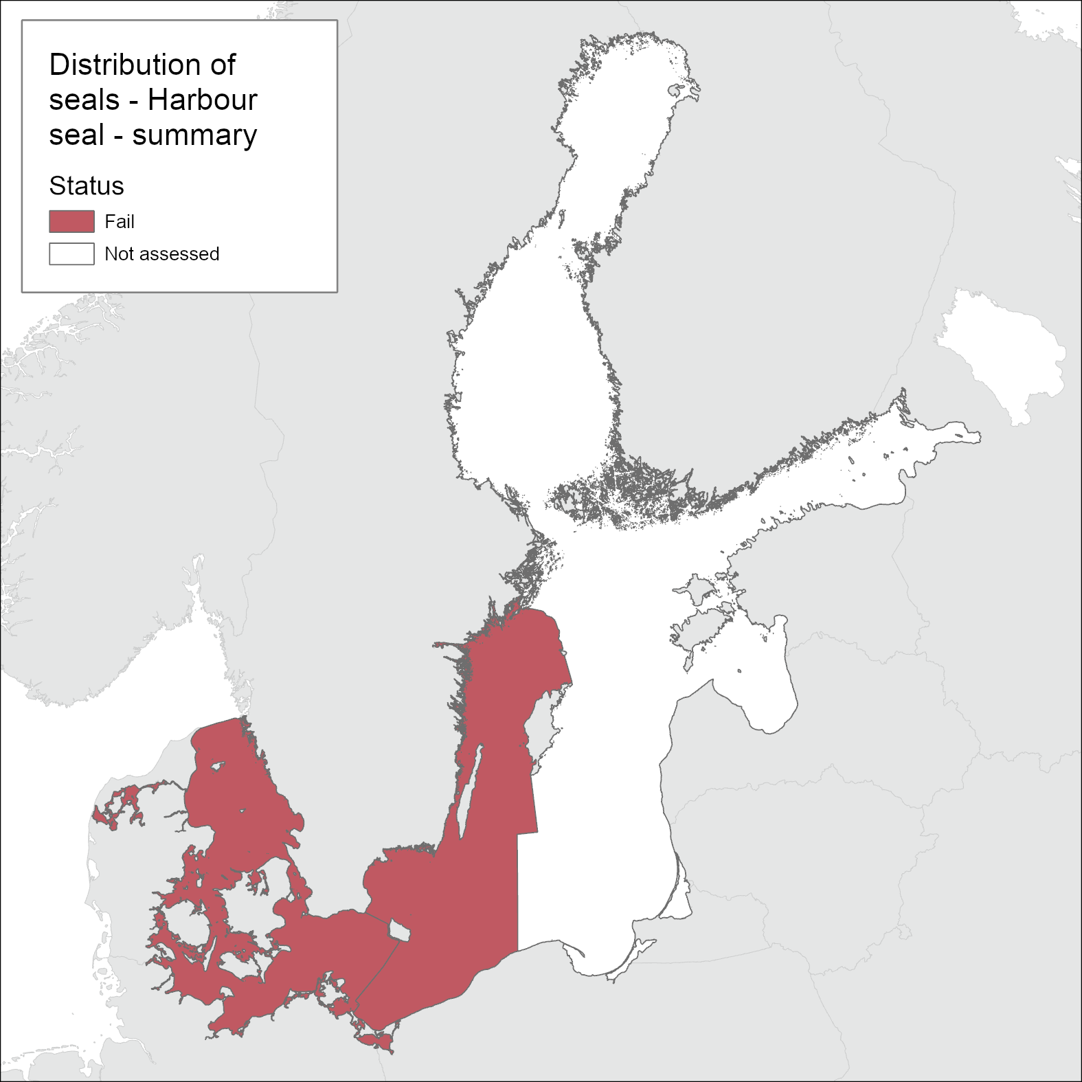
Figure 1. Status evaluation results based on evaluation of the indicator ‘distribution of Baltic Seals’ –Harbour seal. The evaluation is carried out using grouping of scale 2 HELCOM assessment units (defined in the HELCOM Monitoring and Assessment Strategy Annex 4), aggregated to relevant agreed management areas. See ‘data chapter’ for interactive maps and data at the HELCOM Map and Data Service.
State of harbour seals: The state of distribution of harbour seals achieves the threshold value for good status in the Kattegat and Limfjord where the breeding and moulting distribution as well as area of occupancy are at pristine levels. However, good status is not achieved for the SW Baltic, therefore when combined as one management area (HELCOM Recommendation 27/28-2) overall good status is not achieved. The Kalmarsund sub-population fails to achieve good status, since although the area of occupancy (i.e. at-sea distribution) is at pristine levels, not all suitable land sites are used. (Figure 1).
1.1 Citation
The data and resulting data products (e.g. tables, figures and maps) available on the indicator web page can be used freely given that it is used appropriately and the source is cited. The indicator should be cited as follows:
HELCOM (2023) Distribution of Baltic seals – harbour seals. HELCOM core indicator report. Online. [Date Viewed], [Web link].
ISSN 2343-2543
HBCDD
1 Key message
Hexabromocyclododecane (HBCDD)
This core indicator evaluates the status of the marine environment based on concentrations of hexabromocyclododecane (HBCDD) in Baltic Sea fish and sediments. Good environmental status is achieved when the concentrations of HBCDD are below the specific threshold values. The current evaluation is based on data up to 2021, and the status is assessed for the period 2016-2021 (Figure 1).
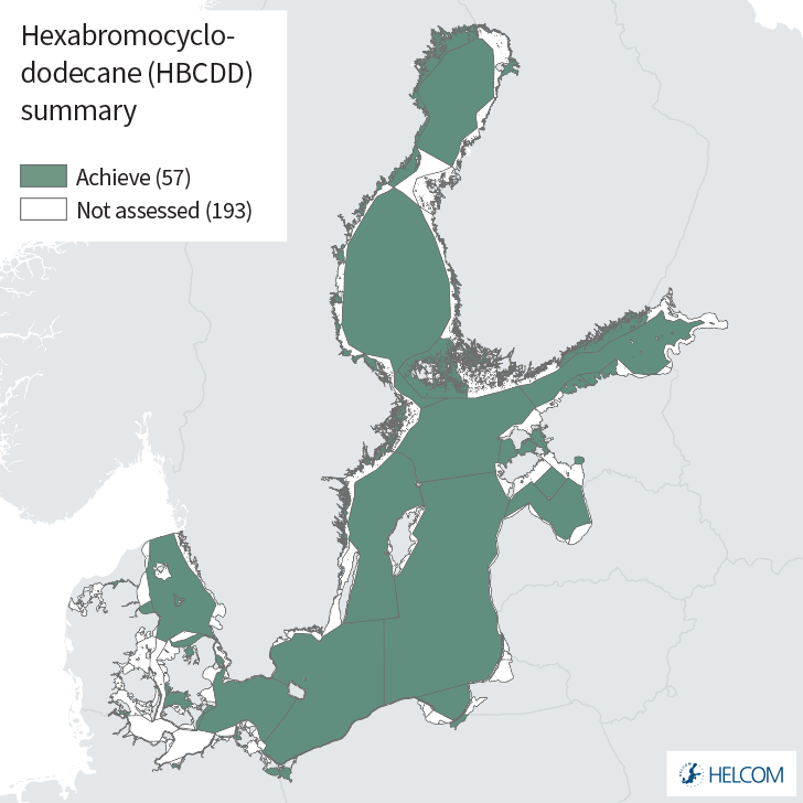
Figure 1. Status evaluation results based on evaluation of the indicator ‘hexabromocyclododecane (HBCDD)’. One-Out-All-Out (OOAO) method, in biota and sediment. The evaluation is carried out using Scale 4 HELCOM assessment units (defined in the HELCOM Monitoring and Assessment Strategy Annex 4). See ‘data chapter’ for interactive maps and data at the HELCOM Map and Data Service.
Good environmental status is achieved for biota and sediments for all assessed areas. This includes 57 assessment units, 12 of which are open sea sub-basins. However, there are areas where data are absent (including open sea sub-basins) and thus more measurements are required to enable a status evaluation across the entire Baltic Sea.
Time series of HBCDD levels in biota showed increasing concentrations since the 1980s in the Baltic Proper and Bothnian Sea (Soerensen and Faxneld, 2022). Within the 22 coastal and marine station in the Swedish Monitoring program for Contaminants in Marine biota where HBCDD is measured every year, 64% of stations show significantly decreasing concentrations over the past 10 years and only one increased. Where long time series data are available this is a general pattern across the region also in this indicator evaluation.
The confidence of the indicator evaluation results is considered to be moderate, with a few assessment units having low confidence. However, it should also be noted that the majority of the stations are selected as reference stations while potential local problems with HBCDD may occur in areas not included in the current monitoring programmes.
The indicator is applicable in the waters of all the countries bordering the Baltic Sea.
1.1 Citation
The data and resulting data products (e.g. tables, figures and maps) available on the indicator web page can be used freely given that it is used appropriately and the source is cited. The indicator should be cited as follows:
HELCOM (2023) Hexabromocyclododecane (HBCDD) HELCOM core indicator report. Online. [Date Viewed], [Web link].
ISSN 2343-2543.
Impulsive sounds
Distribution in time and place of loud low- and mid- frequency anthropogenic impulsive sounds
1 Key message
This indicator is a HELCOM pre-core indicator
This HELCOM pre-core indicator is evaluated for the purposes of the ‘State of the Baltic Sea’ report (HOLAS 3) and further development towards a core indicator is expected in the future. An overview of indicator development is set out in the HELCOM indicator manual.
The indicator ‘distribution in time and space of loud low- and mid-frequency impulsive sounds’ was evaluated in the HELCOM area on the basis of the occurrences of impulsive noise-producing maritime activities reported by Contracting Parties to the regional HELCOM/OSPAR noise registry hosted by ICES. The distribution of sound was partially compared to the distribution of harbour porpoises in the Baltic Sea to get a first idea of overlap of sound and the occurrence of harbour porpoises. Regarding the availability of habitat there should be enough habitat for harbour porpoises to avoid regions impacted by low- and mid frequency impulsive sounds. It will be necessary to determine more details on the sound sources, including a distinction between sonar and acoustic deterrent devices.
This assessment uses methods agreed in HELCOM (HOD 2021) as well as draft methodology and thresholds proposed by the EU MSFD CIS Technical Group on Underwater Noise (TG Noise). At the time of the assessment of this indicator, the concept of the proposed threshold values under consideration for approval on EU-level had been formulated by the EU TG Noise to be based on the evaluation of the temporal and spatial proportion of habitats that are impacted and affected by underwater sound. However, the quantitative threshold values had not been agreed upon. For this reason, the indicator lead proposes to discuss indicator results of this assessment in the light of a proposed interim assessment threshold value of a daily fraction of exposed area of 10% of the Baltic Sea, in agreement with the threshold concept under discussion at EU level during the practical assessment for this report and with the range of quantitative threshold values under consideration for adoption at EU level by the end of finalizing this report. The pre-core indicator is still to be developed in a range of aspects in alignment with EU processes and taking into account regional specificities. While spatial and temporal threshold values have just been adopted at EU level, formal discussions and agreements still remain about the use of these as well as e.g., subbasin and habitat size in the assessment, and sound level of onset of negative effects (LOBE). The indicator will therefore be further discussed and developed towards HOLAS 4.
Across the assessment period the area/habitat exposed and disturbed with respect to displacement clearly remained below a fraction of 10% of the HELCOM area habitat per day. However, for certain shorter time spans, the percentage of total exposed area exceeded this value for several days. A first period occurred in the spring of 2016, where several events occurred simultaneously, including a number of which were long-lasting events that overlapped, and a second period in the spring of 2019. Throughout the entire assessment period the daily exposed area remained below the daily (short term) threshold value developed at EU level of a habitat fraction of 20%. Nevertheless, it should be highlighted that the threshold value developed at EU level provides maximum daily threshold values, recommending further regional adaptions where necessary. Furthermore, the discussion and selection of suitable indicator species and habitats was recommended to be further developed on a regional level. At this moment, further regional work regarding an adaption of the threshold values developed at EU level to the HELCOM region and the continuation of discussions regarding suitable habitats and indicator species is still pending. Furthermore, integration procedures regarding the evaluation of results for different habitats have not yet been proposed.
Based on the available noise registry data, the present indicator assessment covering the HOLAS3 period (i.e. the years 2016 to 2021) shows that a broad range of impulsive sound events occurred in the Baltic Sea region. Based on knowledge gained by several scientific studies, in particular the impulsive noise generating events of high intensity (mostly referring to explosions, acoustic deterrents and also unmitigated pile driving) can have effects on species and their populations in the Baltic Sea, including disturbance and injury. Due to a lack in methodology for a quantitative analysis of impulsive noise with respect to injury, the applied interim assessment threshold value of this indicator assessment concerns disturbance only. However, the risk of injury in noise sensitive species is a relevant concern and needs to be addressed in future assessments.
There are no clear trends observed across the period for the prevalence of events related to any of the different source activity types. The number of airgun array events (repeated impulsive sources used in seismic exploration) varies strongly between years but does not show a general increase or decrease. However, in 2016, a very high relative number of explosion events were recorded, in 2017 a high relative number of pile driving events took place, and in 2020 sonar or acoustic deterrent events were high compared to other years.
Approximately half of the events reported during the period 2016 – 2021 yield a value code of medium or higher (i.e. in the higher categories of reported data, see methods section).
Regular monitoring and reporting of impulsive noise to the regional noise registry was initiated in most HELCOM Contracting Parties in 2015. However, since the reporting completeness of impulsive noise events in the noise registry cannot be readily quantified at this point, the reported numbers of events might represent a fraction of the actual occurrence of events in the Baltic Sea. This remains a known caveat of this indicator and regional as well as national measures to improve the reporting completeness are desirable.
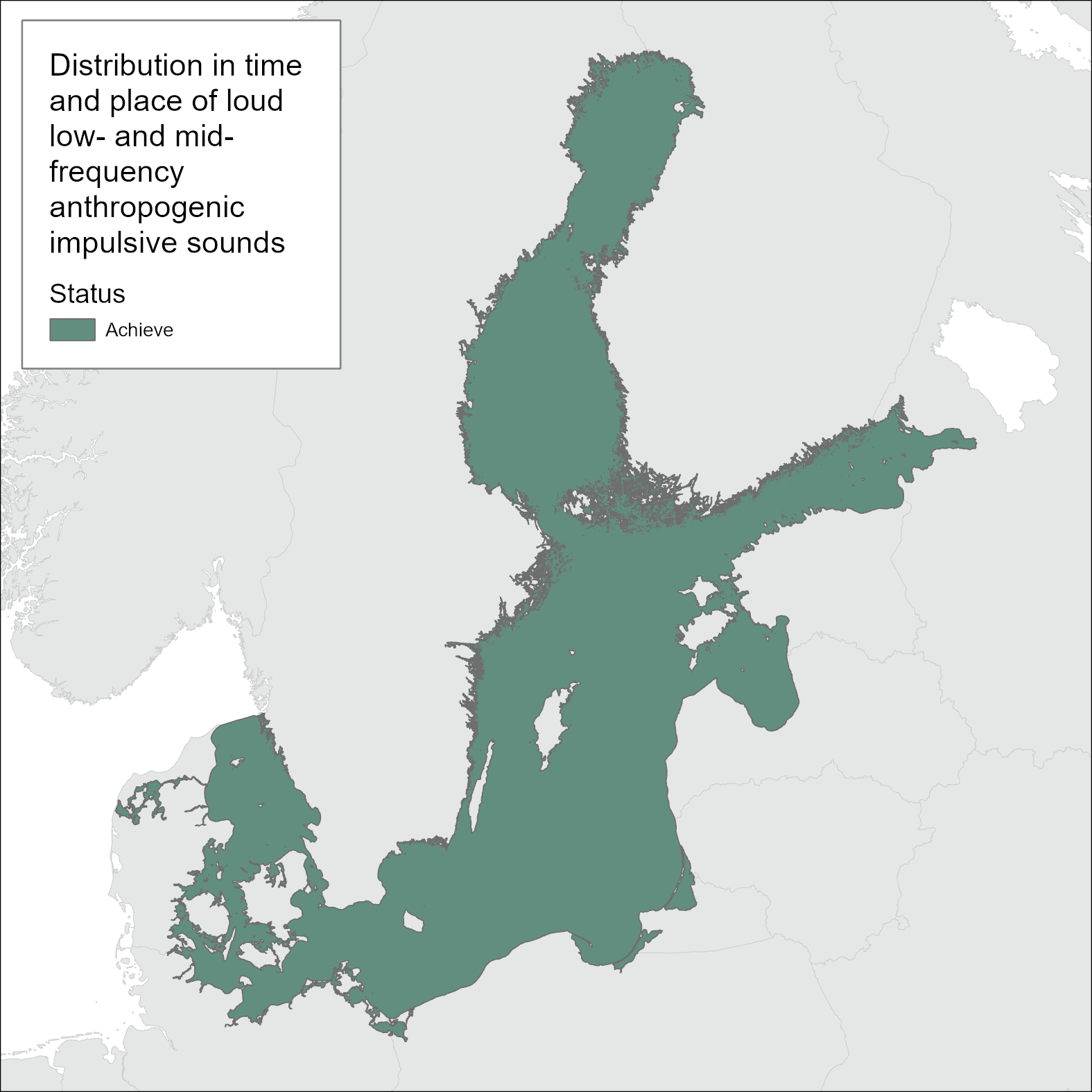
Figure 1. Impulsive noise assessment with respect to disturbance below (green) or above (red) according to the proposed interim assessment threshold value of a daily fraction of exposed area of 10% of the entire Baltic Sea. For background information on the development of threshold values and the choice of relevant Habitats and levels of biological relevance, see section 3 and 4.8. The assessment has been carried out using Scale 1 HELCOM assessment units (defined in the HELCOM Monitoring and Assessment strategy, 2013, Attachment 4). See ‘data chapter’ for interactive maps and data at the HELCOM Map and Data Service.
1.1 Citation
The data and resulting data products (e.g. tables, figures and maps) available on the indicator web page can be used freely given that it is used appropriately and the source is cited. The indicator should be cited as follows:
HELCOM, 2023. Distribution in time and place of loud low- and mid- frequency anthropogenic impulsive sounds. [HELCOM core indicator report]. Online. [Date Viewed], [Web link].
ISSN 2343-2543
Inputs of nutrients
Inputs of nutrients (nitrogen and phosphorus) to the sub-basins 1995-2022
Key message
A significant reduction of nutrients input has been achieved for the whole Baltic Sea. This assessment shows that the normalized total input of nitrogen[1] was reduced by 11% and phosphorus by 32% between the reference period (1997-2003) and 2022 (see key message table 1 and Results figure 1, section 4). The corresponding reductions were 12% for total inputs of nitrogen and 30% for total phosphorus. The maximum allowable input (MAI) of nitrogen and phosphorus was fulfilled in the Bothnian Bay, Bothnian Sea, Danish Straits and Kattegat by 2022 (Key message figure 1 and Results tables 2a and 2b). In the Gulf of Riga, the fulfilment of MAI for nitrogen and phosphorus cannot be judged taking into account uncertainty on inputs. In Baltic Proper and Gulf of Finland MAI was not fulfilled for either total nitrogen or total phosphorus. The MAI indicate the maximal level of annual inputs of water- and airborne nitrogen and phosphorus to Baltic Sea sub-basins that can be allowed while still achieving good status in terms of eutrophication.
Key message figure 1. Total input of nitrogen and phosphorus to each sub-basin (PLC divisions, see Methodology Section 9) and the whole Baltic Sea (BAS). Trend-based estimate of total nitrogen and phosphorus inputs in 2022 (tons per year) including statistical uncertainty are compared with the maximum allowable nutrient inputs (MAI t/y, shown as a black line). Green colour indicates that estimated inputs including uncertainty during 2022 were lower than MAI, red colour indicates that inputs were higher, while yellow indicates that when taking into account the statistical uncertainty of input data it is not possible to determine whether MAI was fulfilled. The percentage in the bar indicates estimated inputs in 2022 including uncertainty in percentages of MAI. Note: the scales on the y-axes differ in the charts.
Key messages table 1. Statistically significant changes (in %) by 2022 in airborne, waterborne, total nitrogen inputs since the reference period (1997-2003) and the corresponding changes for waterborne and total phosphorus inputs. Statistically significant decrease if the numbers are negative. “-“= no significant changes.
| Changes in | Changes in | Changes in | Changes in | Changes in | |
| airborne N | waterborne N | total N | waterborne P | total P | |
| inputs since | inputs since | inputs since | inputs since | inputs since | |
| 1997-2003 | 1997-2003 | 1997-2003 | 1997-2003 | 1997-2003 | |
| Bothnian Bay | -38 | -14 | -18 | -17 | -18 |
| Bothnian Sea | -36 | -19 | -26 | -27 | -23 |
| Baltic Proper | -36 | 8 | -9.7 | -28 | -26 |
| Gulf of Finland | -34 | – | – | -49 | -48 |
| Gulf of Riga | -33 | – | – | -34 | -32 |
| Danish Straits | -37 | -19 | -23 | -23 | -22 |
| Kattegat | -39 | -29 | -28 | -21 | -20 |
| Baltic Sea | -36 | – | -11 | -33 | -32 |
The structure of the indicator follows the standard template for HELCOM Core indicators describing relevance of the indicator in chapter 2 and threshold values in chapter 3. Drivers, activities and pressures related to this indicator are introduced in chapter 6. Results of the annual data assessment are in chapter 4, confidence of assessment results in chapter 5, importance of climate change and other factors for the indicator in chapter 7, and the conclusions in chapter 8. Description on methodologies behind data and the assessment is summarized in chapter 9, and the assessed data is introduced in chapter 10.
1.1 Citation
HELCOM (2024) Inputs of nutrients to the sub-basins (2022). HELCOM core indicator report. Online. [Date Viewed], [Web link].
ISSN 2343-2543
Authors
Lars M. Svendsen1, Bo Gustafsson2, and Søren E. Larsen1
With support from the HELCOM Reduction Scheme Core Drafting Group (RedCore EG)
1 DCE – Danish Centre for Environment and Energy, Aarhus University
2 Baltic Nest Institute, Sweden

Lead
1 Key message
Lead (Pb)
This core indicator evaluates the status of the marine environment based on concentrations of lead (Pb) measured in seawater, biota and sediments, in the Baltic Sea. Good Environmental Status (GES) is achieved when the concentrations of lead in specified matrices are below the specific regionally agreed threshold values.
The indicator presents a status evaluation using all monitoring data for the HELCOM region during the assessment period 2016 – 2021 (Figure 1).
Figure 1. Status evaluation results based on the evaluation of lead concentrations. One-Out-All-Out (OOAO) method incorporating seawater, biota and sediment. The evaluation is carried out using Scale 4 HELCOM assessment units (defined in the HELCOM Monitoring and Assessment Strategy Annex 4). See ‘data chapter’ for interactive maps and data at the HELCOM Map and Data Service.
Lead (Pb) is evaluated in 159 assessment units, including all seventeen sub-basins and the threshold value is achieved (in GES) in 28 of these assessment units, including two open sea sub-basin (SEA-014 Åland Sea and SEA-015 Bothnian Sea). Failure to achieve the threshold value occurs in all three monitoring matrices (water, biota and sediment), contributing to this overall evaluation (generated via a one-out-all-out, OOAO) approach. Where distinct directional trends were possible to assign the downward trends (decreasing concentrations, 16) outnumbered those stations with identified upward trends (increasing concentrations, 3), and in general the majority of these station also achieve the threshold value and were in GES (14 out of 19 being in GES).
The confidence of the indicator evaluation is moderate, with a few assessment units achieving high or low confidence. The data on metal concentrations is generally spatially adequate and time series are available for several stations.
The indicator is applicable in the waters of all countries bordering the Baltic Sea.
1.1 Citation
The data and resulting data products (e.g. tables, figures and maps) available on the indicator web page can be used freely given that it is used appropriately and the source is cited. The indicator should be cited as follows:
HELCOM (2023) Lead. HELCOM Core Indicator Report. Online. [Date Viewed], [Web link].
ISSN: 2343-2543

Mercury
1 Key message
Mercury (Hg)
This core indicator evaluates the status of the marine environment based on concentrations of mercury in biota (fish muscle and mussel soft tissue) in the Baltic Sea. Good status is achieved when the concentrations of mercury are below the regionally agreed threshold values.
The indicator presents a status evaluation using all monitoring data for the HELCOM region during the assessment period 2016 – 2021 (Figure 1).
Figure 1. Status evaluation results based for mercury concentrations in fish and mussels. The evaluation is carried out using Scale 4 HELCOM assessment units (defined in the HELCOM Monitoring and Assessment Strategy Annex 4). See ‘data chapter’ for interactive maps and data at the HELCOM Map and Data Service.
Mercury (Hg) concentrations in fish muscle exceeded the threshold level in all 16 (of 17) evaluated open sea assessment units. In addition, of the 124 coastal assessment units evaluated all but 2 failed to achieve the threshold value (i.e. only two were in Good Environmental Status, GES). The assessment units where GES was recorded were GER-010 and DEN-216, coastal areas of the Great Belt and Bornholm Basin, respectively.
The confidence of the indicator evaluation is moderate, with high confidence in certain assessment units. The data on mercury concentrations is spatially adequate and time series are available for several stations across the region.
The indicator is applicable in the waters of all countries bordering the Baltic Sea.
1.1. Citation
The data and resulting data products (e.g. tables, figures and maps) available on the indicator web page can be used freely given that it is used appropriately and the source is cited. The indicator should be cited as follows:
HELCOM (2023) Mercury. HELCOM Core Indicator Report. Online. [Date Viewed], [Web link].
ISSN: 2343-2543

Non-indigenous species
1 Key message
Trends in arrival of new non-indigenous species
Thirteen new non-indigenous species (NIS) or cryptogenic species (CS) have appeared for the first time in the Baltic Sea during the assessment period 2016-2021. Since the threshold value between good environmental status (GES) and not good environmental status is no new introductions of NIS per assessment unit through human activities during a six year assessment period, the indicator trends in arrival of new non-indigenous species does not reach GES, as can be seen in Figure 1.
The Baltic Sea assessment units in which these new NIS/CS have been recorded are the Kattegat, Great Belt, Kiel Bay, Bay of Mecklenburg, Bornholm Basin, Gulf of Gdansk, Archipelago Sea and Gulf of Finland. The new species have been detected both during regular environmental monitoring activities, as well as research surveys and citizens science observations. The data have been verified by national experts. The indicator is only considering new human-mediated introductions and thus the secondary spread by natural means (migration, water currents etc.) within the Baltic Sea is not specifically part of this indicator.
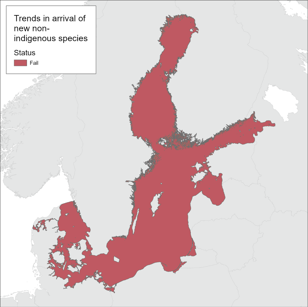
Figure 1. Status evaluation results based evaluation of the indicator ‘Trends in arrival of new non-indigenous species’. The evaluation is carried out using Scale 1 HELCOM assessment units (defined in the HELCOM Monitoring and Assessment Strategy Attachment 4). See ‘data chapter’ for interactive maps and data at the HELCOM Map and Data Service.
The trend in arrival of new NIS/CS has been increasing since the beginning of the 1900s, generally indicating a clear anthropogenic impact on the Baltic Sea environment. It may also be due to more intense monitoring activities. However, there has been an increase in the number of new NIS/CS detected during the current assessment period (thirteen) as compared to the previous one (2011-2016, twelve). This pattern is complicated by reporting of records from the previous period that took place subsequent to the completion of the previous indicator evaluation. The main human induced pathway, in addition to introduction by natural means, associated NIS/CS is maritime transport.
Routine monitoring does not cover all invasion hotspots, habitats and taxonomic groups in many of the countries surrounding the Baltic Sea. The confidence in the evaluation for areas where detections of new NIS/CS have been made is high. In assessment units where no observations were recorded, the confidence may be low if no regular monitoring is conducted. This however varies between assessment units. However, the overall confidence is considered moderate for the evaluation made since the available records clearly show that the threshold value has not been achieved.
The indicator is applicable in the waters of all countries bordering the Baltic Sea but can be considered as fully operational only in the assessed areas and habitats supported by proper monitoring data.
1.1 Citation
The data and resulting data products (e.g. tables, figures and maps) available on the indicator web page can be used freely given that it is used appropriately and the source is cited. The indicator should be cited as follows:
HELCOM (2023). Trends in arrival of new non-indigenous species. HELCOM core indicator report. Online. [Date Viewed], [Web link].
ISSN 2343-2543

Nutritional status of seals
1 Key message
Nutritional status of seals
This core indicator evaluates the status of the marine environment in terms of the nutritional status of seals, measured as average blubber thickness of seal populations based on data collected on hunted grey seals (Halichoerus grypus). This signals both long-term and short-term changes in food supply and many other stressors. Good status is achieved when the subcutaneous blubber thickness is above the defined threshold value, which reflects good conditions. In the current evaluation (2016-2021) the grey seal failed to achieve the threshold value for both hunted (Figure 1) and bycaught seals (Figure 2) and the population is thus in not good status for the whole Baltic Sea.
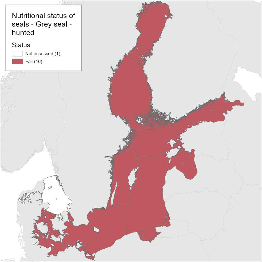
Figure 1: Status evaluation results based on evaluation of the indicator ‘nutritional status of seals’ 2016-2021. The evaluation is carried out using aggregated Scale 2 HELCOM assessment units – whole Baltic Sea excluding the Kattegat and Limfjord (defined in the HELCOM Monitoring and Assessment Strategy Annex 4). Status evaluation is carried out based on standardized samples of blubber thickness observations in hunted grey seals and a threshold of 40 mm is used. See ‘data chapter’ for interactive maps and data at the HELCOM Map and Data Service.

Figure 2: Status evaluation results based on evaluation of the indicator ‘nutritional status of seals’ 2016-2021. The evaluation is carried out using aggregated Scale 2 HELCOM assessment units – whole Baltic Sea excluding the Kattegat and Limfjord (defined in the HELCOM Monitoring and Assessment Strategy Annex 4). Status evaluation is carried out based on standardized samples of blubber thickness observations in bycaught grey seals and a threshold of 35 mm is used. See ‘data chapter’ for interactive maps and data at the HELCOM Map and Data Service.
Grey seals(Halichoerus grypus) occur in the entire Baltic Sea area, though in Kattegat the species is rare and has not been breeding since the 1930s, except for a few observations in recent years. The status of the grey seal in the Baltic Sea is evaluated as a single unit, excluding Kattegat, which is evaluated separately. Grey seals do not achieve the threshold value with regard to nutritional status when evaluated as one single population at the scale of the entire Baltic Sea.
Ringed seals (Pusa hispida botnica) occur in the Gulf of Bothnia (northern management unit), and the Gulf of Finland, Archipelago Sea, Gulf of Riga and Estonian coastal waters (southern management unit). The status of ringed seals is not evaluated for these two management units in this evaluation and no thresholds have been established.
Harbour seals (Phoca vitulina) are confined to the Kalmarsund (Western Gotland Basin and Bornholm Basin), Western Baltic Sea (Arkona Basin, Bay of Mecklenburg, Kiel Bay, Great Belt, the Sound), the Kattegat and Limfjord; each of which are separate management units. The Kattegat and Limfjord subpopulations may be approaching carrying capacity since the annual population growth rates are levelling off. Threshold values with regard to blubber thickness are not finally determined and no status evaluation is made in the current evaluation.
The indicator described here is applicable in all HELCOM sea regions since the grey seal population can be considered as a shared population. However, it should be noted that due to migration patterns, fishery activities and national hunting regulations, the shared seal population is exposed to different pressures in different areas.
The indicator is applicable in the waters of all the countries bordering the Baltic Sea since the indicator includes one or more marine mammal species that occur in all HELCOM assessment units. In the current document, only the grey seal nutritional status is directly assessed and the status evaluation for the entire Baltic Sea region is extrapolated from data gathered from Finland and Sweden (including the southern parts of Sweden). Improved data coverage is needed. Reported data was also present from parts of Germany and Denmark, however age determinations were lacking. Future improvements of the indicator can assess if age determinations are indeed necessary.
1.1 Citation
The data and resulting data products (e.g. tables, figures and maps) available on the indicator web page can be used freely given that it is used appropriately and the source is cited. The indicator should be cited as follows:
HELCOM (2018) Nutritional status of marine mammals. HELCOM core indicator report. Online. [Date Viewed], [Web link].
ISSN 2343-2543
Oil spills
1 Key message
Oil spills detected through aerial surveillance affecting the marine environment
The indicator evaluates the status of the marine environment with respect to Oil spills detected through aerial surveillance affecting the marine environment. The threshold value is based on estimated volumes of oil introduced to the Baltic Sea from such discharges during a defined reference period (2008-2013). The volume of oil is considered to be the most relevant metric to evaluate the effect of oil spills on the marine environment.
In the assessment period of 2016-2021 the estimated annual average volume of oil exceeded the threshold value in the Bothnian Sea, Gdansk Basin, Western Gotland Basin and the Kattegat (Figure 1). The threshold value is defined based on a modern baseline using the reference period 2008-2013 when the estimated volume of oil was considered to be at a historically low level.
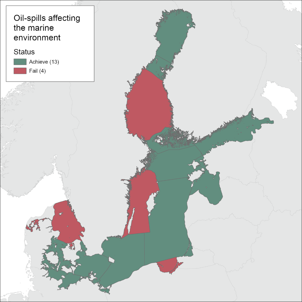
Figure 1. Status evaluation results representing the evaluation of the indicator ‘Oil spills detected through aerial surveillance affecting the marine environment ‘. The evaluation is carried out using HELCOM Scale 2 HELCOM assessment units (defined in the HELCOM Monitoring and Assessment Strategy Annex 4). See ‘data chapter’ for interactive maps and data at the HELCOM Map and Data Service.
Both the number and the size of oil spills detected through annual aerial surveillance shows decreasing trends in all sub-basins. This validates that the measures implemented in recent years have been successful in decreasing the pressure on the environment caused by oil spills. Detected oil spills are principally found along the main shipping routes.
Aerial surveillance of oil spills has been carried out by Contracting Parties of HELCOM for several years with standardized methods, weekly covering nearly the entire Baltic Sea. The confidence of the indicator evaluation is therefore considered to be high. However, a decline in flight hours in recent years might be expected to have a negative effect on the confidence and this issue is a topic that EG Surveillance would evaluate in future assessments, as required, to ensure confidence remains high.
1.1 Citation
The data and resulting data products (e.g. tables, figures and maps) available on the indicator web page can be used freely given that it is used appropriately and the source is cited. The indicator should be cited as follows:
HELCOM, 2023. Operational oil spills from ships. HELCOM core indicator report. Online. [Date Viewed], [Web link].
ISSN 2343-2543
The indicator name was changed from Oil spills affecting the marine environment” to “Oil spills detected through aerial surveillance affecting the marine environment” based on a request from WG RESPONSE 9-2026.
Oxygen debt
1 Key message
Oxygen debt
This core indicator evaluates average oxygen debt below the halocline that separates deep water from the surface water. Oxygen debt is applied in the Bornholm Basin and Baltic Proper (containing Gdansk Basin, Western Gotland Basin, Eastern Gotland Basin, Northern Baltic Proper and Gulf of Finland Western assessment units). Neither of these assessment areas have achieved oxygen debt values below the threshold value (Figure 1).
Oxygen debt below the halocline has increased in all basins since the early 1900s. The increase has been strongest in recent years since the early 1990s.
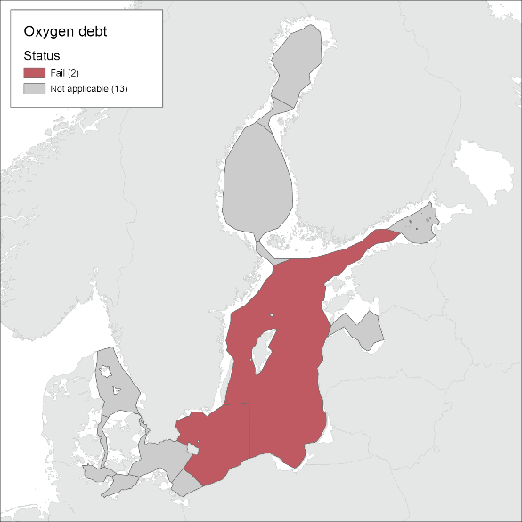
Figure 1: Status evaluation results based on evaluation of the indicator ‘Oxygen debt’. The assessment is carried out using open sea areas of Scale 4 HELCOM assessment units (defined in the HELCOM Monitoring and Assessment Strategy Annex 4). See Results section below for details. See ‘data chapter’ for interactive maps and data at the HELCOM Map and Data Service.
The confidence of the presented oxygen debt status estimate is high in all the sub-basins where the indicator was applied.
1.1 Citation
The data and resulting data products (e.g. tables, figures and maps) available on the indicator web page can be used freely given that it is used appropriately and the source is cited. The indicator should be cited as follows:
HELCOM (2023). Oxygen debt. HELCOM core indicator report. Online. [Date Viewed], [Web link].
ISSN 2343-2543.

PAHs and metabolites
1 Key message
Polyaromatic hydrocarbons (PAHs) and their metabolites
The concentrations of benzo(a)pyrene, anthracene and fluoranthene representing the concentration of polyaromatic hydrocarbons (PAH), achieve the threshold value in ten out of the assessed 15 open sea and in 73 of 95 coastal assessment units (Figure 1).
In general a larger proportion of evaluations in the sediment monitoring matrix (evaluations of fluoranthene (circa 17% of assessment units) and anthracene (circa 42%)) exhibited concentrations above the threshold value (i.e. failed to achieve Good Environmental Status, sub-GES) as compared to evaluations carried out in biota (fluoranthene and benzo(a)pyrene, both circa 3% of the evaluated assessment units).
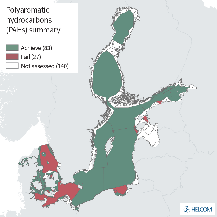
Figure 1. Status evaluation for the indicator ‘PAHs and their metabolites’. The summary map provides a One-Out-All-Out (OOAO) overview of benzo(a)pyrene in biota, fluoranthene in biota, fluoranthene in sediment, and anthracene in sediment. PAH metabolites are not included in this summary but are presented in the results section below, with further details on each component. The evaluation is carried out using Scale 4 HELCOM assessment units (defined in the HELCOM Monitoring and Assessment Strategy Annex 4). See ‘data chapter’ for interactive maps and data at the HELCOM Map and Data Service.
The concentrations of PAH metabolites are evaluated in a few assessment units (9) and generally fail to achieve the agreed threshold value in open sea assessment units where evaluated (sub-GES). The evaluation of PAH metabolites is not included in the overall summary but present independently in the results section and also utilised to support analyses of biological effects.
The confidence in the indicator evaluation is mainly moderate, with a few assessment units showing low or high overall confidence (see details below). The evaluation offers a broad coverage of the Baltic Sea region and is carried out using all available data for the period 2016-2021.
The indicator is applicable in the waters of all countries bordering the Baltic Sea.
1.1 Citation
The data and resulting data products (e.g. tables, figures and maps) available on the indicator web page can be used freely given that it is used appropriately and the source is cited. The indicator should be cited as follows:
HELCOM (2023). PAH and metabolites. HELCOM core indicator report. Online. [Date Viewed], [Web link].
ISSN 2343-2543
PBDEs
1 Key message
Polybrominated diphenyl ethers (PBDEs)
The available observations and data evaluation show that the concentration of polybrominated diphenyl ethers (PBDEs) is high in biota (but not in sediments) compared to the threshold throughout the Baltic Sea. The status of the sum of PBDE congeners (28, 47, 99, 100, 153 and 154) in fish, during the period 2016 to 2021, shows that the threshold is exceeded at every monitoring site in the Baltic Sea where biota is evaluated, resulting in all fish monitoring areas being classified as ‘sub-GES’ (failing to achieve Good Environmental Status). One assessment unit is below the threshold value (in GES) but in this case, only an evaluation in sediments was carried out for this area (Figure 1). The core indicator threshold value is the EU Environmental Quality Standard (EQS) of 0.0085 µg kg-1 wet weight (ww) in fish. The threshold is considered to be very precautionary and is due for review by the EU Chemicals Working Group.

Figure 1. Status results based on the evaluation of the indicator Polybrominated diphenyl ethers (PBDEs). Status evaluations are provided as a summary using the One-Out-All-Out approach. The evaluation is carried out using Scale 4 HELCOM assessment units (defined in the HELCOM Monitoring and Assessment Strategy Annex 4). See ‘data chapter’ for interactive maps and data at the HELCOM Map and Data Service.
Concentrations of single PBDE congeners are declining, but the availability of long time series is limited in the Baltic Sea and concentrated in the western parts of the region.
The confidence of the indicator evaluation is in general moderate, with high or low confidence identified for a few of the assessment units evaluated.
The indicator is applicable in the waters of all countries bordering the Baltic Sea.
1.1 Citation
The data and resulting data products (e.g. tables, figures and maps) available on the indicator web page can be used freely given that it is used appropriately and the source is cited. The indicator should be cited as follows:
HELCOM (2023). Polybrominated diphenyl ethers (PBDEs). HELCOM core indicator report. Online. [Date Viewed], [Web link].
ISSN 2343-2543
PCBs, dioxins and furans
1 Key message
Polychlorinated biphenyls (PCBs), dioxins and furans
This core indicator evaluates the status of the marine environment based on concentrations of dioxin and dioxin like compounds in Baltic Sea fish, crustacean and molluscs as well as on concentrations of non-dioxin like PCB in Baltic Sea fish. Good status is achieved when the concentrations of PCBs, dioxins and furans are below the threshold values. The current evaluation is based on data available to evaluate the assessment period 2016-2021 (Figure 1).
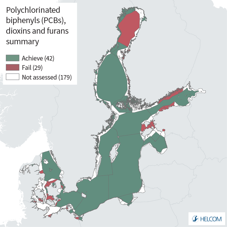
Figure 1. Status evaluation results based evaluation of the indicator ‘PCBs, dioxins and furans’ using the One-Out-All-Out (OOAO) method. The assessment is carried out using Scale 4 HELCOM assessment units (defined in the HELCOM Monitoring and Assessment Strategy Annex 4). See ‘data chapter’ for interactive maps and data at the HELCOM Map and Data Service.
Good status was achieved in the majority of open sea areas (only one of the thirteen evaluated open sea areas failed to achieve the threshold value) and also in many coastal assessment units. In coastal areas the number of assessment units failing to achieve the threshold value and thus not achieving Good Environmental Status (sub-GES) was larger, with 29 of the 71 evaluated assessment units being sub-GES. PCBs as well as dioxins and furans were responsible when the overall good status was not achieved. However, there are areas where dioxins and furans data are absent, or of low abundance and often short time series (i.e. initial data) and thus extended monitoring is required to enable an improved status evaluation in the entire Baltic Sea.
Time series of PCB levels in biota show distinct decreasing concentrations at some stations (circa 15% of stations), for example in the Bornholm Basin, Western Gotland Basin and others. For dioxins and furans the equivalent percentage of monitored stations showing decreasing trends (i.e. lowered concentrations) is circa 8%. However, most of the stations show no significant trends.
The general overall confidence of the indicator evaluation is moderate, though in a small number of assessment units confidence is low. The indicator is applicable in the waters of all countries bordering the Baltic Sea.
1.1 Citation
The data and resulting data products (e.g. tables, figures and maps) available on the indicator web page can be used freely given that it is used appropriately and the source is cited. The indicator should be cited as follows:
HELCOM (2023). PCBs, dioxins and furans. HELCOM core indicator report. Online. [Date Viewed], [Web link].
ISSN 2343-2543
PFOS
1 Key message
Perfluorooctane sulphonate (PFOS)
This core indicator evaluates the status of the marine environment based on concentrations of perfluorooctane sulphonate (PFOS) in Baltic Sea fish and, in a number of assessment units, the secondary matrix seawater. Good status is achieved when the concentrations of PFOS are below the regionally agreed threshold values. The current evaluation considers the assessment period 2016-2021 (Figure 1).
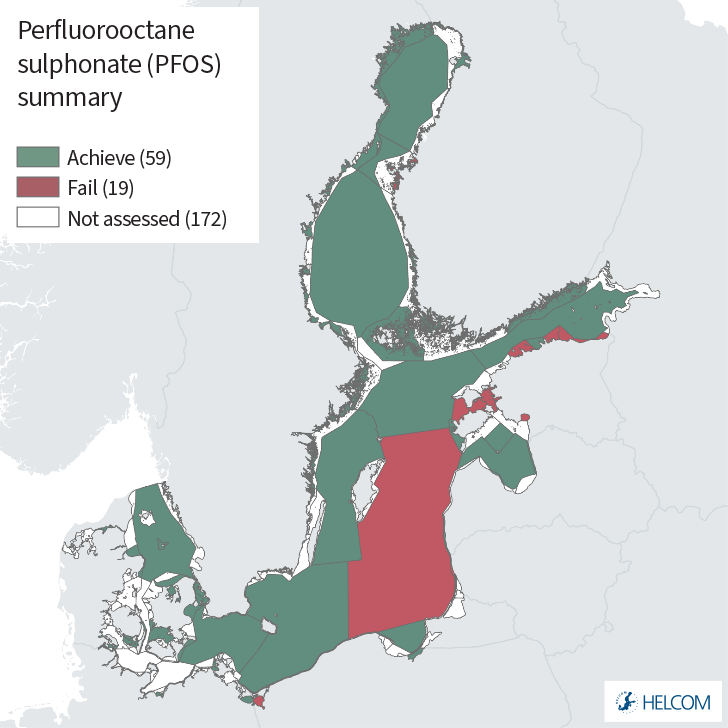
Figure 1. Status results based on evaluation of the indicator ‘perfluorooctane sulphonate (PFOS)’. One-Out-All-Out (OOAO) method, in biota and in seawater. The evaluation is carried out using scale 4 HELCOM assessment units (defined in the HELCOM Monitoring and Assessment Strategy Annex 4). See ‘data chapter’ for interactive maps and data at the HELCOM Map and Data Service.
Figure 1 show the status result for PFOS based on the combined results for biota and water with the lowest status in an area of the two matrixes outranking the better one. Concentrations of PFOS are below the threshold value in biota in almost all the monitored areas, with 68 assessment units evaluated (13 of which are open sea) and only one failing to achieve the threshold value (failing to achieve good environmental status (GES)). However, the concentrations in seawater exceed the threshold value (EQS for water) for all but two of the twenty (only one open sea) assessment units evaluated. The reason for the failure to achieve GES (red areas in the summary key message indicator map; Figure 1) is therefore mostly linked to the failure of the threshold value for water. Using the primary threshold set for muscle concentration in biota, GES is achieved for all evaluated areas, except for the assessment unit FIN-006 in The Quark sub-basin during the assessment period 2016-2021. Data is available from Denmark, Estonia, Finland, Germany, Latvia, Lithuania, Poland and Sweden but there are still smaller areas where data are absent (both open sea and coastal assessment units at HELOCM Level 4) and several areas are evaluated based on only one or few years of monitoring data (especially for water). Therefore, increased monitoring frequency is needed to enable a more complete evaluation throughout the entire Baltic Sea.
Time series of PFOS levels in biota show increasing concentrations since the 1970s and 1980s in the Baltic Proper and the Bothnian Sea. However, in the most recent ten-year period stable or decreasing concentrations of PFOS are observed across the Baltic Sea. Where distinct trends could be assigned in the current analysis this is also what is observed in biota at individual stations.
The confidence of the indicator evaluation results is considered to be moderate with some specific assessment units being of low or high confidence.
The indicator is applicable in all Baltic Sea waters.
1.1 Citation
The data and resulting data products (e.g. tables, figures and maps) available on the indicator web page can be used freely given that it is used appropriately and the source is cited. The indicator should be cited as follows:
HELCOM (2023) Perfluorooctane sulphonate (PFOS). HELCOM Core Indicator Report. Online. [Date Viewed], [Web link].
ISSN 2343-2543

Phytoplankton
1 Key message
Seasonal succession of dominating phytoplankton groups
This indicator is a HELCOM pre-core indicator.
This HELCOM pre-core indicator is evaluated for the purposes of the ‘State of the Baltic Sea’ report (HOLAS 3) and further development towards a core indicator is expected in the future. An overview of indicator development is set out in the HELCOM indicator manual.
The status evaluation has been done for specific assessment units over the period 2015–2020 (Figure 1). The threshold values, based on defined reference periods, assess acceptable deviations from seasonal growth curves of dominating phytoplankton groups. The indictor value is based on the number of data points which fall within the acceptable deviation range, as set for each monthly phase in the reference growth curve and expressed as the percentage to the total number of observations. Strong deviations from the reference growth curves indicate impairment in the environmental status.
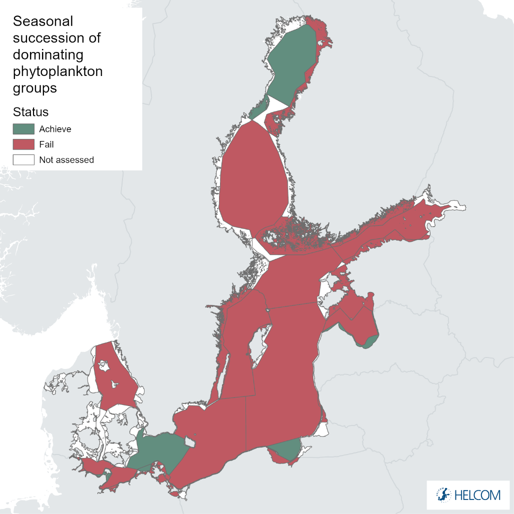
Figure 1. Status evaluation results based evaluation of the indicator ‘Seasonal succession of dominating phytoplankton groups’. Due to national database issues Danish phytoplankton data are not included in this evaluation. German costal waters are displayed based on WFD results. The evaluation is carried out using Scale 3 HELCOM assessment units (defined in the HELCOM Monitoring and Assessment Strategy Annex 4). See ‘data chapter’ for interactive maps and data at the HELCOM Map and Data Service.
To develop basin-specific threshold values, all data were analysed to detect periods with lower total biomass and lesser year-to-year fluctuations. This indicator should be applicable also in coastal and open sea waters around the Baltic Sea. The analysis for 27 assessment units resulted in threshold values varying from 0.55 to 0.79 (Table 2). Most of the evaluated areas do not show good environmental status (GES), as seen in the figure 1.
Where applied, the confidence in this indicator evaluation is high or intermediate.
1.1 Citation
The data and resulting data products (e.g. tables, figures and maps) available on the indicator web page can be used freely given that it is used appropriately and the source is cited. The indicator should be cited as follows:
HELCOM (2023). Seasonal succession of functional phytoplankton groups. HELCOM pre-core indicator report. Online. [Date Viewed], [Web link].
ISSN: 2343-2543
Radioactive substances
1 Key message
Radioactive substances: Caesium-137 in fish and surface seawater
This core indicator evaluates the state of the environment using the concentration of the radioactive isotope caesium-137 (137Cs) in herring, flatfish (flounder and plaice) and surface seawaters. Good status is achieved when concentrations reach levels below the threshold values of 40 Bq m-3 in seawater and 20 Bq kg-1 in fish (based on safety standards). Furthermore, a target level was defined corresponding to concentrations measured before the Chernobyl accident in 1986, the point at which the Baltic Sea environment received the most significant contribution of artificial radionuclides, predominantly in the form of 137Cs.
The indicator presents a status evaluation using data from 2016-2021 (Figure 1).
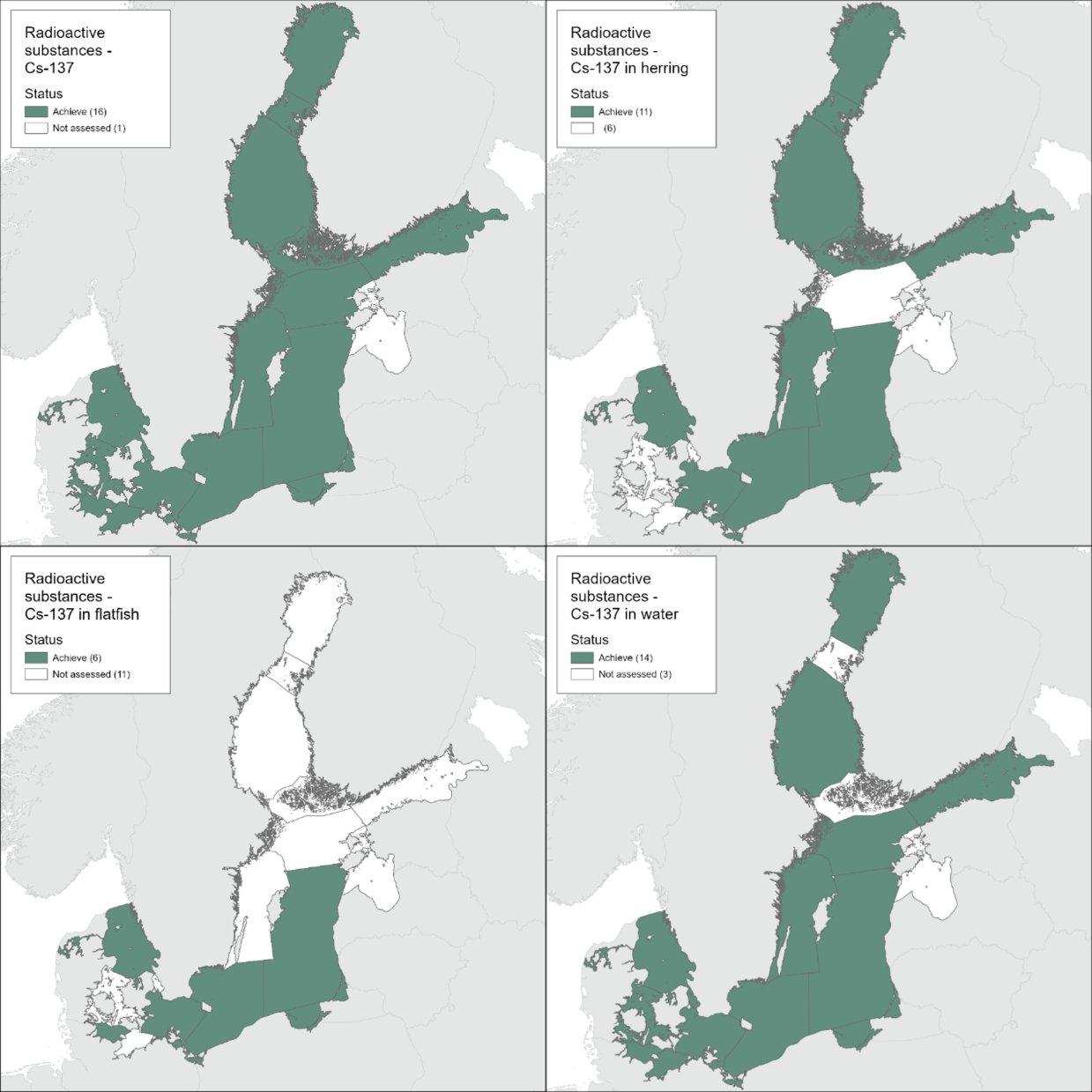
Figure 1. Status evaluation results based on the evaluation of concentrations of caesium-137 in biota (herring and flatfish -flounder and plaice) and in seawater. The One-Out-All-Out approach is used to summarise the status (main figure) and the evaluations are shown for biota (upper insert) and water (lower insert). The evaluation is carried out using the Scale 2 HELCOM assessment sub-basins (defined in the HELCOM Monitoring and Assessment Strategy Annex 4). See ‘data chapter’ for interactive maps and data at the HELCOM Map and Data Service.
In general, the activity concentrations of the radioactive isotope caesium-137 (137Cs) in herring, flatfish and sea surface waters were in most HELCOM subbasins still above the pre-Chernobyl levels, but they are below the good status threshold values of 20 Bq kg-1 in the case of fish and 40 Bq m-3 in the case of seawater and thus the areas assessed are determined to be in Good Environmental Status (Figure 1).
Taking into account the present concentration levels in Baltic Sea biota, no effects on animal health by 137Cs are expected. The lowest effect levels observed in fish (according to ICRP 2008) are more than three orders of magnitude higher compared to the doses estimated to these animals.
Furthermore, time series analyses show that the 137Cs activity concentration in herring, flatfish and surface waters in the Baltic Sea basins are decreasing and approaching the pre-Chernobyl levels, which may be reached in the Baltic Sea around 2025.
The confidence of the indicator status evaluation is considered to be high.
The indicator is applicable in the waters of all countries bordering the Baltic Sea.
1.1 Citation
The data and resulting data products (e.g. tables, figures and maps) available on the indicator web page can be used freely given that it is used appropriately and the source is cited. The indicator should be cited as follows:
HELCOM (2023) Radioactive substances: Caesium-137 in fish and surface seawater. HELCOM core indicator report. Online. [Date Viewed], [Web link].
ISSN 2343-2543